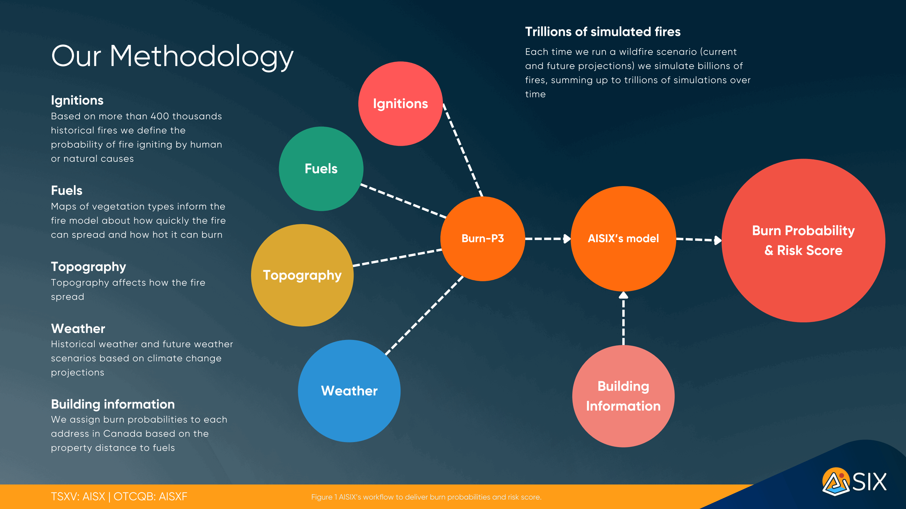
The Wildfire Score for Canada, powered by AISIX, is determined using AISIX’s specialized software developed with Burn-P3+. Burn P3+, also utilized by the Canadian wildfire service, predicts wildfire spread based on climate, topography, and vegetation variables. AISIX incorporates data and simulates multiple wildfire scenarios, integrating them to assess the likelihood of fire occurrence in specific locations or regions over 30-year period.

To model wildfire, AISIX analyzes the historical occurrence of fire based on its geographic distribution and cause (lightning or human), the distribution of fuel types (vegetation), the influence of topography (fires spread more quickly on steep slopes), the past and future weather conditions (temperature, humidity, precipitation, and wind), and the location of buildings and infrastructure. Each scenario undergoes millions of simulations to account for the natural variability and complexity of the landscape. This enables AISIX to provide burn probabilities that accurately capture this complexity.
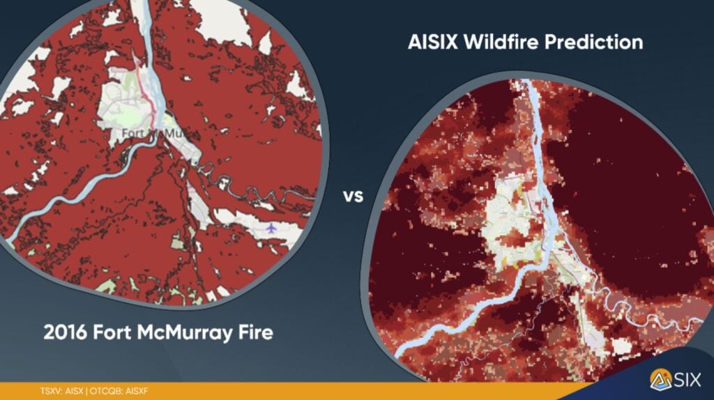
To validate the model, billions of simulated past fires are generated. This involves comparing the historical national burn areas to ensure accurate and reliable results:
Wildfire Fact: Spread and growth of wildfires, as well as its suppression, are influenced by its starting point and weather conditions.
AISIX Score
To enhance the accuracy and transparency of the probabilities, we have implemented a classification system consisting of five distinct levels: 1 to 5. By assigning a higher number to a particular probability, we signify a greater likelihood of its occurrence. Conversely, assigning a lower number indicates a reduced likelihood or possibility of the event taking place. This categorization methodology ensures a clear understanding of the probabilities presented.

Please Note:
AISIX scores are probabilities, which means they are not certain. It’s important to be careful when understanding these scores. Remember that even if something is likely, it is not guaranteed. The opposite is also true. To understand more, please read AISIX disclaimers.
FAQs
- What is a wildfire risk score?
A wildfire risk score is a numerical value assigned to a specific location based on its susceptibility to wildfires. It is calculated using factors like historical wildfire data, vegetation types, climate conditions, and proximity to known fire prone areas. This score helps homeowners, buyers, and insurance companies assess potential risk levels. - How often is the wildfire risk score updated?
AISIX wildfire risk scores are typically updated annually to reflect new data and environmental changes. However, significant events such as major fires or changes in land use can prompt more frequent updates. - How can I use the wildfire risk score when buying or selling a property?
When buying or selling property, the wildfire risk score can be a crucial factor in determining property value and insurance costs. A high risk score might affect pricing negotiations and insurance premiums. Buyers should consider potential mitigation measures and insurance costs associated with higher scores. - What steps can I take to reduce my property’s wildfire risk?
To reduce wildfire risk, maintain a defensible space around your property by clearing away brush, dead leaves, and other flammable materials. Use fire resistant building materials for roofs and exterior structures. Regularly clear gutters and maintain landscaping to reduce fuel for fires. - Is my property’s wildfire risk score based on current weather conditions?
While the base score incorporates historical and geographical data, it may not reflect real time conditions such as current droughts or ongoing wildfires unless specifically stated. For current conditions, check local fire department updates and real time wildfire tracking systems. - Can the wildfire risk score change over time?
Yes, the wildfire score can change due to factors like climatic changes, land development, and improvements in risk assessment technologies. Regular updates incorporate these changes to keep the score as accurate as possible. - Who can I contact for more detailed information about my property’s wildfire risk?
For more detailed information, contact info@aisix.ca. Local fire departments and wildfire mitigation professionals can also provide site specific advice. - What should I do if I disagree with my wildfire risk score?
If you disagree with your score, you can request a review or reassessment. Provide supporting documentation or evidence that might affect the risk assessment, such as recent land changes or mitigation efforts. - Does a high wildfire risk score mean I can’t get home insurance?
A high risk score does not necessarily mean you cannot get insurance, but it may impact your insurance premiums and options. Shop around for insurance providers that specialize in high risk properties. - Where else can I check for wildfire risk information?
For additional information, consult government websites like the Canadian Wildland Fire Information System or province websites like Fire Smart BC. University research centers and environmental organizations also provide data and resources on wildfire risk and management.
Climate Data Disclaimer
The climate data provided on this website is intended to furnish users with general information on the potential impacts of climate-related factors on property values and conditions. This data is
derived from various sources, which may include governmental meteorological agencies, climate change models, and other third-party data providers.
Accuracy and Limitations: AISIX endeavors to offer up-to-date and accurate climate data; however, due to the inherent variability of climate and weather patterns, we cannot guarantee the
absolute accuracy or completeness of this data. The information is provided "as is" without warranty of any kind, either express or implied.
Not a Substitute for Professional Advice: The climate data presented should not be construed as professional real estate, legal, or financial advice. It is intended for informational purposes only,
and should not be relied upon for making decisions regarding real estate transactions or investments. We strongly recommend consulting with a professional real estate advisor or a climate
resilience expert to obtain specific advice tailored to your individual circumstances.
No Liability: Under no circumstances will AISIX be liable for any direct, indirect, incidental, special, consequential, or exemplary damages arising out of or in connection with the use of the climate
data provided. This includes, but is not limited to, damages for loss of profits, goodwill, use, data, or other intangible losses.
Changes and Updates: The climate data on this website may be updated periodically. They reserve the right to make changes or updates at any time without prior notice.
Contact Us: If you have any questions or concerns about the climate data or its implications for a specific property, please contact the AISIX support team at: info@aisix.ca
By accessing and using the climate data on this website, you acknowledge and agree to the terms set forth in this disclaimer.