

The AISIX flood score is derived from flood exposure indices computed for both coastal and fluvial flooding. The score represents property exposure to streamflow and coastal flooding according to precipitation data and topography. The higher the score, the likelier the property is to be impacted by high water levels.
AISIX adapt the Natural Resources Canada (NRCan) methodology for mapping flood exposure across Canada. The dataset captures exposure to coastal and fluvial (river) flooding at a 50 m resolution.
AISIX assign risk scores based on flood exposure. Properties along primary flood paths are the most likely to flood. Properties within high-exposure areas can see similar water depths but flood less often. Properties next to high-exposure areas may still see severe local water depths.
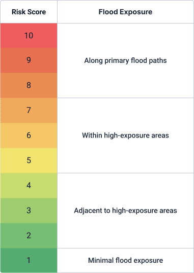
The score reflects flood exposure, not expected damage. Damage also depends on the characteristics of each building, which the score does not account for. For example, a building in a high-exposure area may see little damage during a flood if it has no basement, its first floor is raised above flood level, and it has pumps and flood barriers installed
The data does not explicitly include pluvial flooding, which is surface flooding that happens when intense rainfall overwhelms local drainage. It reflects large-scale rainfall patterns, but not how small-scale terrain can funnel, pool or channel runoff into sudden, deep local flooding. As a result, a low flood score does not rule out flooding during short, intense storms.